CHINA SHOOTS DOWN ORBITING SATELLITE
What Does This Mean To The United States?
Part 2
Satellite signals can be improved for special aviation applications, such as landing planes
during poor visibility. GPS is continually being improved and modernized. It is easy to see that the aviation
industry, particularly the airlines, badly needs GPS. With so many airplanes in the air it becomes increasingly
important to know where they are.
MARINE
GPS has greatly affected marine operations, including search and rescue. GPS provides the fastest and most
accurate method for mariners to navigate, measure speed, and determine location. This increases levels of
safety and efficiency for mariners worldwide.
It is extremely important in marine navigation to know your vessel's exact position while
in the open sea, or congested harbors. The need for accurate position information becomes even more critical
as a vessel departs from or arrives in port. GPS is also used for underwater surveying, buoy placement,
and navigation in a hazard location. Commercial fishing fleets use GPS to navigate to optimum fishing locations,
and to ensure compliance with regulations. Maritime operations also enjoy higher precision and increased
safety using Differential GPS. ( DGPS ). And now we come to perhaps the most important weapon in our arsenal,
the submarine. It is an absolute necessity for the sub to always know its exact position.
Later we will see that the Tomahawk missiles fired by our subs are dependent on GPS to guide them to their
target.
GROUND SURVEYING
A typical engineering company accomplishes ground-based surveying with geodetic-grade ( centimeter accuracy
) GPS receivers operated in static or kinematic mode, depending on project requirements. Trimble mapping-grade
receivers are used for sub-meter accuracy survey work. Also used in surveying are automatic levels, total
station, and theodolites. Horizontal control can be surveyed to 1st or 2nd order accuracy using GPS, while
vertical accuracy with GPS can be surveyed to 2nd order accuracy with precise leveling. Ground surveying
using GPS is used in mapping of highways, railroads, dams, lakes and rivers, airports, transmission lines,
plant sites, landfills, hazardous waste sites, and wetlands to name a few. A large percentage of surveying
work is done utilizing aerial photogrammetry. This requires very expensive equipment, such as modified aircraft,
first order aerial cameras, complete photo lab, rectification systems, and highly qualified personnel. Primary
photogrammetric-grade image acquisition systems require the latest generation USGS-calibrated aerial cameras,
such as the Zeiss RMK TOP 15 with built-in forward motion compensation producing resolution in the highest
range. This camera can be operated using automatic gyrostabilizing mounts which are linked to geodetic-grade
APPLANIX 510 POS/AV airborne GPS/IMU systems which record the exact camera position and spatial orientation
at the instant of each exposure. This produces automated image geo-referencing accurate within inches. The
transition of the captured photo image to the final product requires sophisticated instrumentation operated
by well skilled photogrammetrist. Aerial surveying has progressed at an unbelievable rate in recent years,
and is now an important part of aerial and ground surveying.
MILITARY
Without exaggeration our military would be greatly affected if they did not have GPS. In the Korean war
it was common to send 10 B-29s with 500 pound bombs to destroy a bridge. Many times after bomb damage assessment
( BDA ) photos showed the bridge to be undamaged and another flight was scheduled. It was common for a perfect
bomb run to have its bombs "straddle" the bridge. That is where GPS comes in. With precision guided
weapons the bridge could conceivably be destroyed by one well placed bomb. The U.S. has experimented with
Radio-controlled weapons, laser guided weapons, Radar/infrared/electro-optical, only to arrive at the conclusion
that GPS offered the most accurate delivery system. In some instances TV guided bombs are still being used.
The laser had a disadvantage of not being useable in poor weather. The problem of poor visibility has no
effect on satellite guided weapons. At present it is still possible to jam GPS. Several companies are developing
advanced guidance concepts, combining laser guidance to the GPS guided system.
TOMAHAWK MISSILE
Possibly our most important weapon is the all-weather submarine or ship launched land-attack cruise missile.
Our BGM-109 Tomahawk is such a weapon. It is highly survivable, difficult to detect because of its small
cross section, and its low altitude flight. Infrared detection is difficult because the turbofan engine
emits little heat. The land attack version of Tomahawk has inertial and terrain contour matching guidance.
TOMAHAWK MISSILE FIRED FROM USS MISSOURI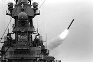 |
TOMAHAWK MISSILE IN FLIGHT |
| SOURCE OF BOTH: DEPARTMENT OF DEFENSE | |
The Tomahawk is a long -range, highly survivable, land attack weapon system capable of pinpoint accuracy. It offers the Navy a deep strike capability. Submarines utilize a different weapon control system to guide the Tomahawk. On the attack submarines, missiles are fired from torpedo tubes. Some of our subs have a vertical launch system located forward, external to the pressure hull, which will handle both storage and launch. Since the Gulf War, the Tomahawk has an increased target penetration, along with better range and accuracy. The GPS guidance control utilizes a jam proof missile. Inventory of Tomahawk missiles is underway with over 4,000 missiles currently in stock. The Tomahawk is built by Hughes Missile System Co. It uses a turbo fan engine which has a solid fuel booster. Weighing 2650 pounds, it has a range of 690 miles at a speed of 550 mph. The Tomahawk production model cost $500,000.
SEAWOLF CLASS NUCLEAR SUBMARINE, U.S. NAVY
By Wayland M. Mayo
Wayland is a Professional Surveyor and Mapper (ret) In the state of Florida.
Chief Photogrammetrist, pilot,(ret) Korea Veteran RB-29 "Tiger Lil."
Sources: U.S. Coast Guard, nav. Center GPS
Library of congress
Associated press
U.S. Department of Defense
U.S. Navy
Wikipedi
| << previous page |